Thursday 30 June 2016

Day 63 - No Pass Day

Red Meadows to Thousand Islands Make - 16.6 miles. Distance from Mexico 923.3 miles

The normal early start was delayed until 9 a.m. as I had to catch the bus back up to Red Meadows from Mammoth at 7.15 a.m. I had breakfast at Red Meadows so it was a leisurely start to my day.
I ducked down a side trail to look at the basalt columns of Devils Post Piles
It satisfied my hunch that the area looked like there had been volcanic activity.
The scenery was spectacular in the afternoon as we worked out way up a ridge that gave splendid views of the ridge opposite the trail. With the Ritter Range resplendent & Shadow Lake hemmed in lower down it was great eye candy. The sharp jagged peaks in the background are the Minarets
I had planned to camp on the shore of Thousand Islands Lake but the campsite was full and breezy. So I worked up the trail 400 yards to find a good spot. That's the Ritter Mountains in the background

Otherwise it was a quiet day apart from bumping into Roller Coaster who I had not seen since Tehachapi.
So no passes today but two tomorrow - Island & Donohue which I will do first thing before heading to Tuolumne Meadows...Weta

Wednesday 22 June 2016

Day 62 - Zero in Mammoth

Pretty cruisy day here getting ready for the next stanza.
Mammoth is like a lot of tourist towns where you find evidence of the original settlement but "progress" has stamped itself with flash high end retail, gated tourist lodges, substantial residential development all catering for the almighty dollar - pretty much like any tourist place in NZ i.e. Mount Maunganui, Queenstown, Taupo etc. Don't get me wrong though - it's a lovely place & you are well catered for. The North Village caters for the high end
They also have these cool free shuttle buses that get you around
Plan is to head to Tuolmne Meadows in the next 2 days. I then go off trail for 3 to 4 days to head down Yosemite Valley to Half Dome, Yosemite Falls etc. Might even get a permit to climb Half Dome. Talk is that we will have to deal with snow for a while yet with some ice shutes north of Sonora Pass causing concern. Until then...Weta

Day 61 - Nero in Mammoth

Mile 901  to Red Meadows - 5.7 miles. Distance from Mexico 906.7 miles

A comfortable trot to Red Meadows in the morning with a view of some spectacular peaks to enjoy
Red Meadows is at the end of one of the tentacles of the octopus that is Mammoth. The bus shuttle took us firstly to the main ski area of Mammoth which is super impressive
It's holiday time here so the skifield is still running along with mountain bike tracks. Mammoth Mountain itself has 25 chair lifts, 2 gondolas, 2 t bars & a pomas.
A 2nd bike shuttle took us in to Mammoth itself - very touristy & very Queenstown like. Also the place seems very new. I checked in to the local hostel (very chilled) & got some chores done including gear repairs at Mammoth Mountaineering who were brilliant.
Tomorrow I'll plan for the next section & do a resupply etc...Weta

Day 60 - A Pass Too Far

Mile 878.7 to Mile 901 - 22.3 miles

With 7 passes crossed in 6 days, something has to give - me!!! I was absolutely shattered at days end and am thankful for a short 5.7 miles to Red Meadows tomorrow where I'll catch the shuttle to Mammoth. The climbing, the snow (mostly soft & slushy) & the creek crossings did the damage today. Almost 4700 feet of climbing tested this kiwi. From a 5.30 am start it took 4 hours to go 6 miles to summit Silver Pass at 10937 feet. It was typical JMT stuff with big switchback climbs and the massive giant steps. Three fords in the first 2 miles meant cold wet feet. The second one was potentially lethal with fast flowing white water while the 3rd was virtually under a waterfall
The snow was getting soft as the pass loomed centre of picture. It was actually to the left up a valley then a final climb to the right
The view just down from the summit was amazing - we dropped down in to the valley and later in the day would sneak around the tree lined lower mountains on the distant right
Getting down from the pass was a battle of snow & finding the trail (no snow trail markets on the JMT). At Fish Creek we thankfully had a steel bridge to cross the menacing water
This started a tough 1200 foot climb to Lake Virginia
Now we have a Virginia Lake back in my spiritual home of Whanganui which I think wins the contest...just.
A pleasant surprise were a couple of double log bridges which I vote we should have more of
Having bemoaned the lack of snow markers, Dairy Queen pointed out to me that blazes carved in to the trees were JMT markers...doh!!!!!
We also passed 900 miles today which means I've done 100 miles in the last 5 days. In the Sierras!!!! Not sure that was in the plan. Anyway - it's summer solstice and a full moon so will retreat to the tent before weird stuff happens....Weta


Day 59 - Long Miles & Bugs

Mile 854.5 to 878.7 - 24.2 miles

A long day in the saddle - and a strange one. I saw no other PCT hikers all day!! Not even at my final campsite at Mono Creek. I guess I'm just caught in a void between groups of hikers. The only folk I saw were southbound JMT hikers including a couple of Aussies. All were keen to find out about pass conditions and depth of fords.
The day started at 6.00 am with a 3000 foot climb ahead of me to reach Selden Pass at 10910 feet. It was one of those mornings when I felt in the groove and was surprised to top the pass after 11 miles at 10.45 am. The actual pass did not come into view until the last minute
And from the top the view from where I had been
and where I was heading - including truckloads of snow to plough through....yay
A few miles later I tackled the famed Bear Creek  - not wide but fast flowing and managed to get only wet up to my crotch with my gear nice & dry.
Later in the day the killer blow was an unwelcome 1000 foot climb to cross from the Bear Creek Valley to Mono Creek Valley. The long switchback down the other side would've been lethal for southbounders but the trees were impressive
I am hopeless with tree identification but best guess includes Ponderosa Pine, Cedar, Ash, Sugar Pine, Douglas Fir etc. Also impressive were these spores??
They would randomly grow amongst the ground litter.
The one constant today has been bugs. Every time I stopped to hydrate/rest I was immediately besieged by all the bugs in humanity - mosquitos, midges & gnats as an aerial attack & ants being the ground force - particularly the big black swine that are aggressive as hell. The campsite was worse with these microscopic lice type things over everything. I lost my rag on a few occasions (an under-estimate).
I should get close to Red Meadows tomorrow. I'm looking forward to a breather at Mammoth where I have a number of gear issues to sort & repair...Weta


Tuesday 21 June 2016

Day 58 - Another Day. Another Pass.

Mile 832.6 to Mile 854.5 - 21.9 miles

It was the turn if Muir Pass today. At 11973 feet it was the last time we touch 12000 feet until Washington...I think!! The pass was not overly difficult - we just had to deal with a lot of snow either side of the high point. There was probably 6 miles of snow in total. The pass is up to the right of this photo
The final push with Double Double leading the way
And out reward...this cool little hut with Double Double the human interest
The 6.00 am start was rewarded with the snow hard packed, making the climb easier but it was pretty slushy by the time I took off my snow spikes at about 11.30 am.
At my lunch spot at Evolution Lake there was a change in topography with the typical hemmed in shot
replaced by the wide open Evolution Valley ahead of me
It was like you could see the sky without it competing for space with the mountains (although I am hemmed in again late in the day next to the San Joaquin River).
A feature of today was water - starting with the Kings River hurtling down this bluff
 Later in the day I had to ford the Evolution Creek - no biggie except it was about 50 metres wide and going like a fast moving train. A sign said that during high water there was an alternative begging the question though - how do I know if it is high water?? So in I went. The middle section took some strength and the water was up to my crotch but I got across safely. Which was a good thing as a few hundred yards down the creek, the water plunges 100s of feet down a chasm. Later and luckily this bridge saved me the ignominy of wading across the San Joaquin River
The other success of the day was getting a marmot to stand still :-)
Talking of animals, the deer here are astonishingly timid. They have no fear of humans as you can't pick them off with a rifle up here. As for the coyote I saw yesterday, he wasn't hanging around. Neither was the snake on tbe trail that scared the bejesus out of me today. Selden Pass tomorrow with a 3000 foot climb...Weta

Day 57 - John Muir Trail Experience

Mile 811.8 to Mile 832.6 - 20.8 miles

With the PCT following the John Muir Trail (JMT), I can now understand why this trail is world recognised. From mountain passes to glacial lakes to roaring waters to majestic valleys to towering peaks - today had it all. The early part of the day saw us in typical JMT scenes. This was looking back where we'd come from...a valley on the left
And looking forward
Our first task was Mather Pass at 12096 feet
You can see the zig zag on the left. It wasn't too difficult apart from scrambling up some loose rocks which wasn't ideal. From the top we could see a lot of snow in the glacial valley ahead down to Pallusade Lakes. I chatted to a German guy at the summit who had worked in Stratford building a power station!!
The descent was made easier by using micro spikes fitted over my shoes. The early start meant the snow crust was still icy
Credit where credits' due...the JMT steps were much better
Pallisade Lakes were simply stunning and a great place for a lunch refuel
Above the lake the towering Pallisades looked inviting for climbers
A few miles later I came around a bend and oh wow...!!!
The Pallisade Creek Valley stretched before me with a drop down to the floor requiring some inventive switchbacks - a bit like those mountain passes in the Tour de France
Walking down the valley and then round to the right was simply stunning. Towering precipitous steeples of rock 1000s of feet in the air glowering at you from both sides of the canyon with the thundering Pallisade Creek (later the Middle Fork of Kings River) made for a jaw dropping afternoon. The snow melt made for thundering spectacles as water crashed down steep bluffs with fury.
Waterfalls never translate well to photos but this shot gives you an idea of what I mean...
With side streams overflowing I was saved a swim by this bridge
A magnificent day in simply indescribable scenery with a 2500 foot climb to 12000 beer over a snow covered Muir Pass tomorrow morning...Weta

Day 56 - BEAR!!!!

Mile 793.5 to Mile 811.8 - 18.3 miles

I'd wondered if I would ever encounter a bear on this trek. Wonder no more!! About 2/3 up the long haul to Pinchot Pass I got to a flat area with some grass and rocks when just like that....a bear wanders in to my line of sight no more than 20 metres away - a black bear although this one was tan coloured and large. I stopped and reached in my pocket for my phone to take a picture but as I keep it in a zip lock the sound alerted the bear who gave me the once over (figured I looked old and chewy) and wandered off in to the trees and out of view. Whoah!! That got the adrenaline flowing...
The rest of the day wasn't quite as dramatic as we had a long 7.3 mile uphill to rise 3600 feet to reach Pinchot Pass at 12139 feet.
While there was a bit of snow, it was not as bad as Glen Pass & the view ahead from the top held no fears either
I've got as far as the base of the climb to Mather Pass, which I can tackle first thing tomorrow. I'm camped next to the South Fork of Kings River.
Earlier in the day I had a rare surprise. Having spent the last week crossing creeks on stones or logs or just ploughing through them in my jandals, we had......a bridge!!!!
I still had to ford at least 4 rivers today in my jandals.
Also, just after the 800 mile mark at the beginning of the climb, I came across this water shute in Woods Creek
The water was fair barreling down this rock slide. In fact, for the first 3 miles of the climb, we had the creek for company as it roared with snow melt in endless cascades, waterfalls & rapids...very impressive. Weta

Day 55 - Pass Busting

Mile 788.9 to Mile 793.5 - 4.6 miles

Once again, the miles in the PCT don't reflect the effort, remembering I had to walk 7.5 miles & climb Kearsarge Pass again just to get back on trail.
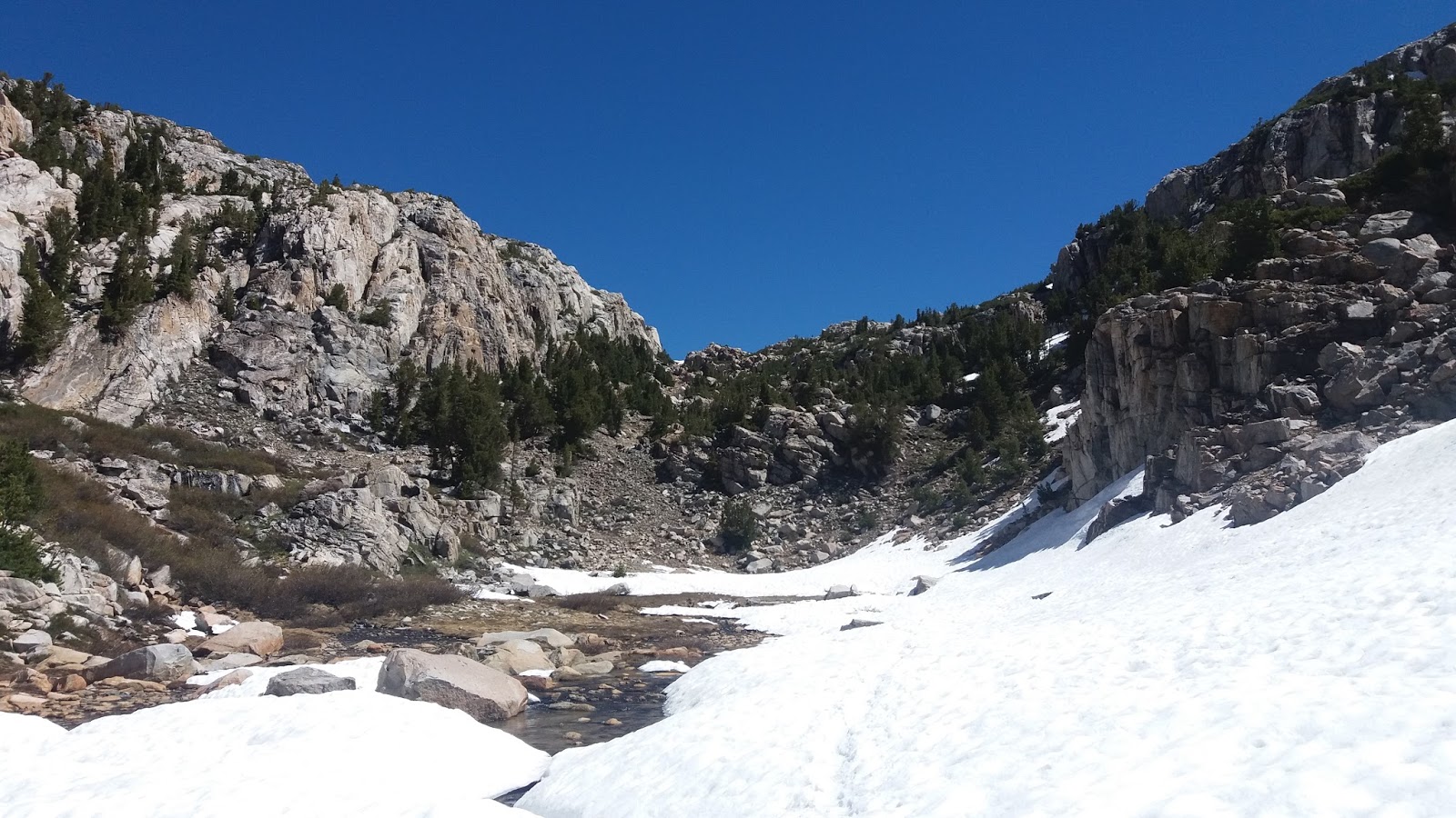
The 4.6 miles in the PCT was brutal though. In this section of the Sierras I'd planned to summit one pass per day & going by today's effort that will be more than enough. Glen Pass is not the highest or longest at 11947 feet but all the recent snow made it trecherous as you can see from the photo north of the summit.
South of the summit wasn't as snowy but it's steep drop made it very dicey
The ascent was going fine until the last 200 metres where switchbacks were covered with snow. This meant a lot of slippage in the afternoon sludge and crawling on all fours at times to avoid the goo. At the top of the summit conditions were atrocious with a viciously cold and gale force wind. This also made balance difficult as the wind would catch the pack & toss you sideways. This got worse as the descent was hampered by soft snow and post-holing (at one stage I had to work for 5 minutes to free my leg). The whole descent was nerve wracking being so slippery and cold. The final destination of Rae Lake couldn't arrive quickly enough
Although at 10750 feet the campsite was sheltered with a view of the imposing Fin Dome across the lake
Earlier in the day I hitched out from Bishop to get back on trail. A climbing couple from Tehachapi Scott & Jody (& Django the dog) took me as far as Independence. Heaving the pack from the car I grabbed the wrong strap and broke a clip which I have jury rigged until I can replace it at Mammoth.
After 45 minutes Max from Keller in his 1980 Mercedes squeezed 4 hikers in to his steed & took us to the trail head by 9.30 am, which was an excellent result.
The trip back along Onion Valley Trail was quite eventful. I met a couple from Wanaka who were hiking the Sierras. At the summit of Kearsarge Pass I bumped into a great hiking duo - Ranger (as a survival skills tutor he knows heaps) & All Smiles (says it all) who I hadn't seen for weeks. A cool couple

On the drop down I ran into part of my original group with Mommy (Jessica), Captain, Tea Time (Ben), Geoff & Daniel heading for the exit. Of the others, Goldfish has caught up & is one day behind me. Topo is 1/2 days ahead I think & Bad Mash?? Banjo was spending 2/3 days in Bishop as he was dog tired.
One last thing. Whomever built the John Muir Trail figured we would one day be all 9 feet tell. The steps used at times would do the Great Well of China proud - lifting your feet above waist height to climb is energy sapping.
Pinchot Pass tomorrow - 3500 feet over 7 miles....Weta

Tuesday 14 June 2016

Day 54 - Zero in Bishop

Bishop is a clean busy little place sandwiched in the Owens Valley between the Sierras to the west
and the White Mountain ranges to the East
Highway 395 through the town heads north to eventually reach Reno while south takes you in to the Mojave. Having gone from no degrees in the Sierras to about 33 degrees today has been a shock to my personal thermometer. Apparently it can get up to over 40 degrees which makes sense as Death Valley is only a couple of valleys east.
For the hiker it is great with good outdoor equipment retailers (it's a big area for climbing), Vons Supermarket & loads of eateries including the usual McDonald's, Carl's Jnr, KFC, Dennys, Taco Bell & bakeries, pizza places, a Texas BBQs etc.
There are a lot of Stetson hats in town along with over sized pick up trucks as there looks like a big rodeo championships being contested. Country & Western music seems to the radio of choice with an upcoming festival having Dwight Yoakam head-lining - I think I have an L.P. around somewhere.
I've planned for a 7 day sojourn to Red Meadows where I can get to Mammoth Lakes for my next stop - and my pack weight reflects that.
With zero coverage in the Sierras that means another week of blog on hold until getting into Mammoth....Weta